
Florence Tanui (University of Nairobi), Behailu Birhanu (Addis Ababa University), Dan Olago (University of Nairobi), Seifu Kebede (University of KwaZulu Natal)
The Horn of Africa is experiencing extreme climate shocks and grappling with the need to plan for an uncertain future climate. Sustainable development of groundwater resources in the region is critical for building climate resilience for vulnerable communities, protecting people’s livelihoods in the face of increased climate variability.
However, groundwater resources are often poorly understood and barely monitored, limiting effective decision-making and policy development for the sustainable management of vitally important aquifers. Drs Florence Tanui of the University of Nairobi and Behailu Berehanu of Addis Ababa University describe how REACH research in northern Kenya and the Awash river basin in Ethiopia is addressing this knowledge gap and building new models for informed aquifer management.
Protecting groundwater resources in Turkana County, Kenya
Aquifers can be even more opaque than a black box to users and managers – poor water quality or resource depletion may occur but there is often no concrete information on where the water in an aquifer came from or how it moves below the ground surface. Hydrogeology shines a light into the box.
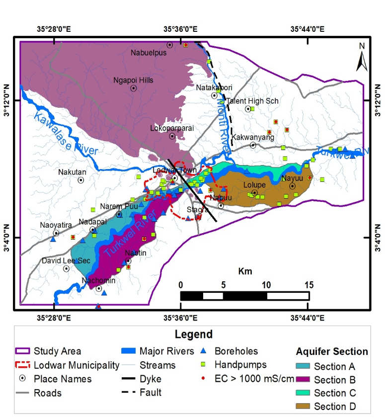
In Turkana county in the northwestern part of Kenya, the REACH programme is using multi-disciplinary risk-based approaches to make the Lodwar Alluvial Aquifer System (LAAS) visible to the people and institutions involved in its management. Methods include hydrocensus, geological mapping, geophysics, hydrogeochemistry, isotope studies, and comprehensive seasonal water quality studies. In combination, these have allowed us to map the interconnected shallow, intermediate and deep aquifers within the LAAS, to estimate its total capacity (around 1.3 BCM) to supply groundwater developments for Lodwar town and its surroundings, and to explore current and future threats to the resource.
Comparing ground and surface water chemistry across the seasons provided insights into the link between the only perennial river in the region (the Turkwel River) and the aquifer. A strong pulse of recharge to the LAAS comes during storms and heavy rainfall in Turkana’s two wet season (March to May and October to December) when the river swells and floods. Patterns of recharge are one way in which a changing climate and more rainfall variability may affect groundwater resources.
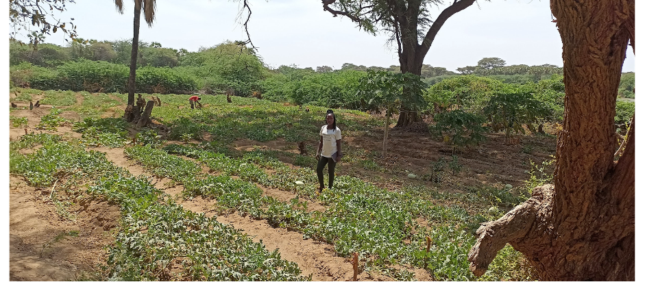
More extreme rainfall events and flooding will also increase the risk of aquifer contamination by human activities. Indeed, wet season samples from the shallow and intermediate aquifer showed increased sulphate and nitrate concentrations, with upstream farming activities a likely major source. Whilst values are currently within guideline values for drinking water, proposed large scale irrigation projects upstream of Lodwar may threaten the aquifers with more contamination. An estimated 91,766 people relied on the LAAS for drinking water in 2019, and by 2030, another 50,000 people are expected to be living in the town. The municipality has no sewage treatment plant, and the proliferation of pit latrines and septic tanks pose more pollution risks.
Groundwater protection and management will be vital to serving the town’s growing population, but with multiple sources of groundwater abstraction and pollution, interventions must be coordinated across many sectors. Ongoing work involves the development of a customized Environmental Monitoring and Management Plan (EMMP) for the LAAS to inform and promote coordination of monitoring activities by all stakeholders. The EMMP manual identifies climate and human-induced risks to the aquifer resource, outlines mitigation activities, and draws a road map to its implementation to protect groundwater supplies.
Read REACH’s Story of Change highlighting work led by the University of Nairobi on protecting Lodwar’s underlying aquifers, the Lodwar Alluvial Aquifer System (LAAS).
Groundwater: An untapped resource for irrigation and water supplies in Ethiopia’s Awash Basin
The Awash River basin is already a basin of extreme climate conditions. Climate modelling projects intensified water stress in future decades, particularly in April-June; a major concern for the irrigation sector and for water allocation amongst all users. Ongoing REACH research aims to assess the implications of climate change on groundwater uses for domestic, industrial, and irrigation purposes in the Awash Basin using integrated modeling techniques.
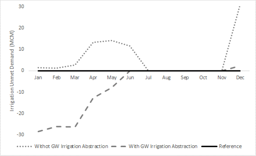
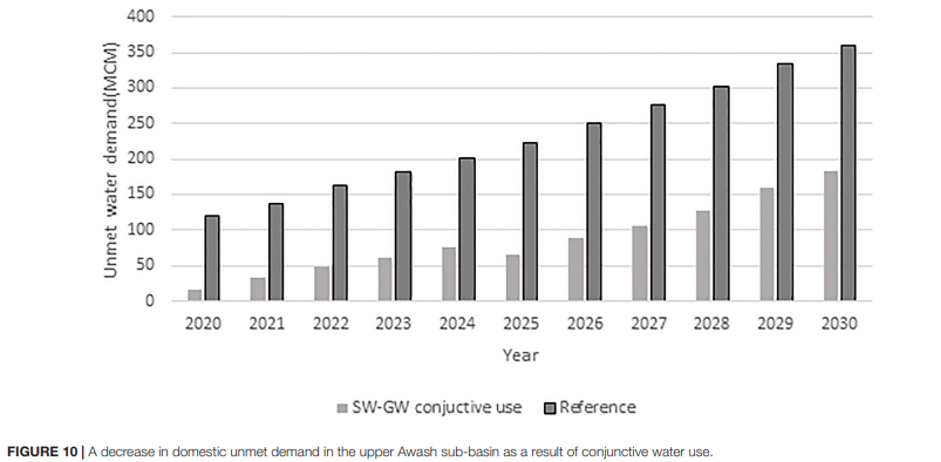
Ethiopia’s agricultural sector is almost entirely based on rain and where there is irrigation, it is mainly from irrigation abstraction from the rivers. The modeling tools we developed for the Awash Basin showed that adding groundwater abstraction for irrigation can reduce unmet irrigation water demand even under drier climate conditions. Even with lower precipitation and increased temperature predicted in future, groundwater irrigation managed to reduce the annual irrigation unmet demand from 393MCM to 294MCM. This indicates that, since climate change affects the surface water flow more than the groundwater storage, groundwater can serve as a resilient water supply alternative for the dry months of the year (Figure 4).
At the time of writing, more than 140 deep boreholes (BHs) (~500m deep) have been drilled in Adaa-Becho (61 BHs), Alliadeghe (41 BHs), and Teru (42 BHs), with the intention to abstract groundwater for irrigation. Based on our impact assessment modeling results, we strongly encourage the responsible government authority to start using the drilled boreholes as an additional water supply source for irrigation, with monitoring and management in place to prevent aquifer depletion that has already been seen in some urban areas of Ethiopia, such as Mekelle, Axum, Harar and Gondar.
Drilling new boreholes will help to resolve chronic interruptions to water services in Ethiopia’s capital city Addis Ababa in the Upper Awash Basin, but only alongside improved and coordinated surface and groundwater management. This will include new surface reservoirs, enhanced monitoring, and new legal frameworks to regulate groundwater abstraction, and engineering investments to reduce leakage from the city’s aging water supply infrastructure.
Conclusion
Findings from REACH’s Lodwar and Awash Basin Observatories illustrate that whilst groundwater contributes to climate resilience, it needs to be understood, protected and managed. Monitoring of groundwater resources over the longer term will permit early mitigation of human and climate risks to groundwater resources, allowing people in the Horn of Africa to make the most of this hidden resource.