
Dr Callum Munday (University of Oxford), Dr Ellen Dyer (University of Oxford), Prof Rob Hope (University of Oxford), Prof Daniel Olago (University of Nairobi), Dr Feyera Hirpa (One Concern Inc.)
Recent news stories predict that the Turkwel Gorge Dam in northwest Kenya will overflow in November 2020. The potential flooding could affect over 300,000 people in an area accustomed to droughts. Understanding rainfall variability can provide lessons for managing dams in drylands to improve water security for energy, agriculture, environmental and human needs.
Lakes along the Great African Rift System from Ethiopia to Tanzania are at their highest levels in decades. The rising water poses multiple hazards including contamination, landslides, and flooding affecting millions of lives.
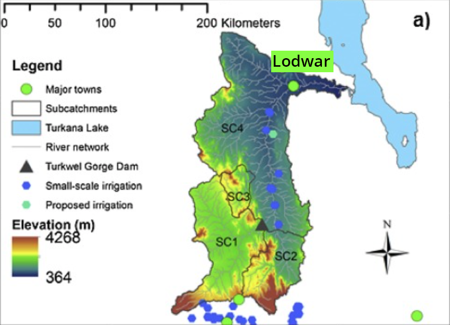
In northwest Kenya, the Turkwel Gorge Dam (figure 1) has reached a historical high, filling to over 92%, with predictions it will overflow at some point in November 2020. The overflow from the dam would cause flooding along the Turkwel River, threatening a number of settlements including the Turkana County capital – Lodwar. The chief executive of the Water Resources Authority, Mohammed Shurie, expects the flooding to affect close to 300,000 people. This is in addition to the 20,000 families already affected by the flooding of Lake Turkana. Understanding the causes of the dam overflow and management responses provides an opportunity to improve climate resilience in the future.
Volatile and extreme rainfall creates difficulties for dam management
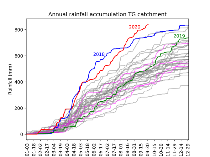
The looming crises is a consequence of a sustained period of high rainfall over the last few years (figure 2) and particularly since October 2019. 2018 and 2019 were the 2nd and 4th wettest years in the last 40 years, while 2020 is on course to be the wettest. The wet conditions of the last year are in contrast to drought conditions and very low reservoir levels during the March-May rainy season in 2019. In July 2019, concerns were raised over the dropping levels of the Turkwel dam. A year later, authorities are warning it could spill over. Managing dam reservoir levels is especially difficult under these volatile conditions.
The extreme rainfall of the last year is due to a combination of climatic factors, which we do not fully understand. This is especially the case for the traditionally drier months of the year from June to September. Ongoing research examining these physical processes suggests that unusually high temperatures in the Indian Ocean may play a part, along with outflows of very humid air from the Congo Basin. Dam operation guidelines developed in the 1980s are unlikely to have fully considered the possibility of changing climate conditions, and rapid transitions between low and extremely high rainfall.
With climate change increasing the likelihood of extreme conditions, management decisions conditioned on past rainfall dynamics are not a good guide for future stresses. Decision makers should expect more events outside the range of observed experience. What does this imply for dam management going forward?
Three areas of action for improving water security
Rainfall hazards in the 1980s during dam construction are substantially different from today, with altered climatic conditions and a fresh set of social challenges. To reduce damages and to improve water security we propose three areas for action.
Tackling information gaps
First, information gaps need to be addressed. The Turkwel catchment has insufficient rainfall monitoring, with a station at the foothill of Mount Elgon 300 km from the next in Lodwar town. It is difficult for dam managers to manage uncertainty without credible and timely data translated appropriately for their work. The majority of rainfall in the catchment falls in the upper zones of Mount Elgon where no observed rainfall data exist.
Better meteorological data can also improve the accuracy of short-term weather forecasts, which are critical for responsive dam management. A robust environmental monitoring plan with stakeholder consensus and public scrutiny will improve water security, if there is political leadership and effective coordination. These are non-trivial conditions.
High rainfall can also be beneficial. Increasing evidence shows extreme rainfall events are associated with high groundwater recharge in many parts of Kenya and Africa. In the semi-arid zones downstream of the dam, groundwater is the critical water resource and a buffer to low rainfall during droughts. Better information and mapping of key recharge zones would help guard against threats from urban or agricultural expansion.
Improving institutional capacity
Second, institutions need to have the capacity and accountability to manage multiple and often competing needs for irrigation, hydropower, environmental flows, livestock and domestic water needs. Information alone will not lead to better decisions. Communicating and sharing climate data with the many uncertainties is a critical step in improving water security. This communication might be particularly important with respect to seasonal rainfall forecasts, which successfully predicted the above average rainfall of the last year. With the dam now full, the set of management decisions is potentially more complex and dangerous than when the dam was close to empty a year ago.
Mapping flood risks and understanding tradeoffs
Third, mapping areas with heightened flood risk can help to prioritise management interventions. If the dam spills with significant flooding this will create damage in flood-prone areas. In Lodwar town, most of the boreholes supplying the people and businesses are located by the river falling in harm’s way. Urban expansion has drifted into zones which are likely to be flooded. The livelihoods of many people in the catchment are closely tied to access to grazing or small-scale farming by the river banks. Flood risk maps would identify vulnerable people and guide future planning so predictable damage is avoided. Often the most vulnerable and least well-informed are at the greatest risk. Floodwater from the dam is also likely to be turbid due to the accumulation of silt and clay which lowers water quality. Lodwar has no alternative water supplies and limited treatment capacity.
The prospect of the dam overflowing in Turkana County comes in the context of the ongoing coronavirus-related disruption and the need to sustainably manage the Turkwel river for all its water users. While there are limited options in the short term, political leaders can take steps to avoid and reduce predictable harm in the future.
If you have any questions please contact:
- Dr Callum Munday, University of Oxford: [email protected] or
- Professor Daniel Olago, University of Nairobi: [email protected]k