
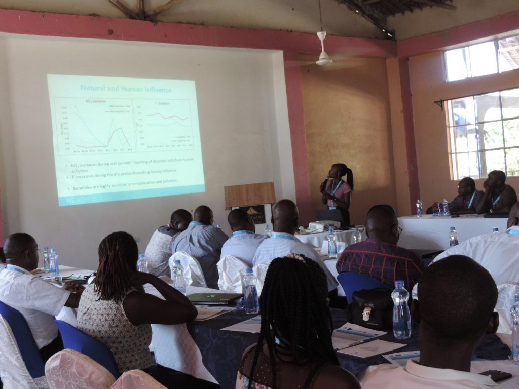
Florence Tanui, University of Nairobi
Groundwater is a hot topic right now. As climate change threatens to alter rainfall patterns, and to increase the occurrence of drought and water scarcity, groundwater is increasingly seen as a vital resource across Africa. But using this ‘invisible resource’ sustainably requires better knowing and understanding it. In this Early Career Researcher feature, Florence Tanui, Ph.D. Fellow in Geology at the University of Nairobi, shares key insights from the groundwater research she has been leading in Lodwar, Kenya, as part of REACH. In addition to her Ph.D. research, Florence has also previously worked in Kenya as a geologist at African Diatomite Industries Limited, and as a Hydrogeologist at Earth Water Limited.
Tell us about how your research relates to REACH?
Throughout my career, I have had a keen interest in understanding groundwater occurrence, water quality, and aquifer processes, to ensure its sustainable use. The on-going groundwater studies in Lodwar and its environs in Kenya’s Turkana County, as part of REACH, are critical to improving water security for the poor.
Lodwar is a good example of a rapidly growing town with high-poverty rates in Sub-Saharan Africa, that depends on groundwater for municipal water supplies. The aquifer holds unique characteristics with its shallow depth coupled with complex geology, hydrology, and the increasing climate variability. Improved understanding of the features of the aquifer as well as current and future availability of water resources in the region are vital to ensure the growing water demand can be met sustainably and benefit the poor.
Why is your research relevant and important in the Kenyan context?
89% of the land area in Kenya – covering 29 out of 47 counties with an estimated population of 16 million – is classified as Arid and Semi-arid Lands (ASALs). For most ASAL areas around the world, surface water is not a sustainable source of water supply. In recent years, drought frequency has been on the rise. In this context of drought and water scarcity, groundwater is increasingly being recognised as a valuable resource for water supply in rural and urban areas of the country. There is a growing need to understand the country’s groundwater; this has led to many groundwater initiatives in recent years, including, the very recent establishment of the Kenya Groundwater Mapping Programme (KGMP) that aims to build science-based knowledge of the aquifer systems.
In 2013, Radar Technologies International (RTI) led a regional groundwater mapping in northern and central Turkana County. The mapping reported an aquifer with an approximate storage capacity of 10 billion cubic meter underlying Napuu village in Lodwar. My Ph.D. research includes a detailed investigation of the hydrogeological, hydrogeochemistry, and water quality of the aquifer, as well as the role of rainfall variability.
The scientific evidence generated throughout my research aims to address knowledge gaps to ensure the sustainable use of the aquifer. The outputs of this study include: understanding of the groundwater occurrence, aquifer geometry, and recharge characteristics including the recharge zones, seasonal water quality, and pollution sources.
What have been some of the early findings for your research?
Investigation of the Lodwar Alluvial Aquifer System (LAAS) has not been an easy task due to the limited reliable secondary data. This led to the collection, storage, and transportation of over 430 bottles of water samples by air that included anions, cations, isotope and duplicate samples for 108 sampled sites as well as rock samples. Despite these data collection challenges, important key findings have been achieved from the investigation:
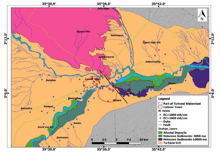
- 1. Interestingly, the Lodwar Alluvial Aquifer comprises two unique systems east and west of the Lodwar municipality, on either side of the Turkwel River. The eastern aquifer is separated from the western one by highly tough volcanic rocks known as the nepheline phonolite linked to the dyke identified to define the boundary of the two systems (Figure 1). This finding differed from the initial finding by the RTI (2013) that suggested the Lodwar aquifer was within the Napuu village of Lodwar Municipality.
- 2. The study estimates that 1.3 billion cubic meters can be stored in the LAAS, with the safe groundwater abstraction of this aquifer expected to be 10% of the total storage capacity. This 10% threshold is referred to as the sustainable yield that can be utilized without causing unacceptable environmental, economic and social challenges.
- 3. This study has also confirmed that there are two shallow groundwater systems (depth = <30 m) in the region; the shallow alluvial aquifer (SAA) hosting potable freshwater and the Turkana Grit Shallow Aquifer (TGSA) that hosts saline groundwater. The SAA is along the Turkwel river while the TGSA is further inland and is not linked to the Turkwel River.
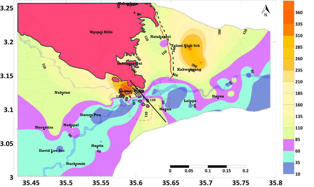
- 4. The sustainability of the LAAS depends largely on the Turkwel River catchment management and protection. This investigation confirmed the hypotheses advanced by Hirpa et al. (2018) and Olago (2018) that the Turkwel river and the Kawalase lagga are responsible for keeping the LAAS fresh and potable as seen in the Water Quality Index map (Figure 2).
What aspects of your research are you particularly excited about?
Limited knowledge is a key challenge towards achieving sustainable groundwater management around the world, and especially in Sub-saharan African. I believe my research can make a major contribution to the on-going groundwater investigations in Africa.
It will also provide key information and the tools necessary to support land use planning and allocation of groundwater in towns located in arid and semi-arid areas in Africa and other parts of the world. Beyond defining the extent, hydrogeochemistry, influence of seasonality changes on water quality, recharge characteristics and age of groundwater in the Lodwar alluvial aquifer, this research will also determine the groundwater recharge zones with the aim of listing them as protected areas in Kenya.
Overall, I have gained a lot of experience both in the application of field techniques, laboratory methods, and utilization of tools of data interpretation. Constant interaction with the community, sectoral practitioners, water managers, decision and policymakers has greatly enhanced my engagement and communication skills as well as my knowledge-sharing technique.